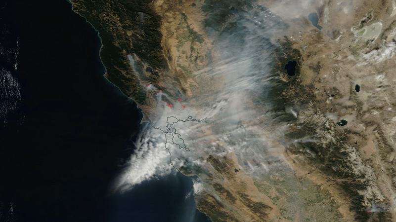
The fires of October 2017 were the most catastrophic in California history. In a state where wildfires extract an annual toll on homes, lives, and property public and private, that’s saying something. At last count, in the course of ten days, 17 coterminous conflagrations had incinerated 250,000 acres; 5,700 structures; and 42 lives—collectively the deadliest wildfire in the United States since the 1918 Cloquet Fire in northern Minnesota. One hundred thousand people were evacuated and 185 hospitalized across seven California counties. Early predictions of long-term economic impact exceeded $85 billion.
The simultaneous ignition of so many fires, all within a few hours and miles of one another—not uncommon in high mountains like the Sierra Nevada, where lightning strikes are the cause— was unprecedented in the North Coast. As of this writing, no one knows what triggered them; various theories are under investigation, including arson and faulty power-line maintenance. There’s no doubt, however, as to what powered them after they were touched off. In California, where the Mediterranean climate includes six months of annual drought between April and October, there’s no such thing as a “good” fire season: Low-rainfall years obviously have very flammable conditions, but wet winters result in heavier vegetation, which translates into heavy fuel loads when it dries out in summer. This year, the latter was the case after record rains ended a multiyear drought (which had killed thousands of trees). Typically the North Coast has westerly winds whose marine influence brings fog and some humidity, but when the desiccated late-summer landscape receives the rarer Diablo winds, which blow west from the even drier interior, fire danger reaches “red-flag” levels.
Encompassing freakish 50-mile-per-hour gusts, this was the scenario on the night of October 8 and morning of October 9. When fires started on Atlas Peak, northeast of the town of Napa, and in Redwood Valley in Mendocino County, the wind didn’t just fan the flames; it drove them. It took only three hours for the Tubbs Fire, which started near Calistoga in northern Napa Valley, to reach the city of Santa Rosa 14 miles away. The blaze sped over wooded hills and down ravines paralleling Mark West Springs Road and Fountaingrove Parkway, devouring a mobile home community and—stoked by swarming embers—jumping across US 101 to annihilate 1,500 homes in the neighborhood of Coffey Park.
“Vineyards are great defensible space—a fire usually doesn’t pass right through a vineyard. It penetrates a short distance and stops.”
—Carole Meredith
This was the scene of the fire’s most apocalyptic images: a leveled townscape of building foundations, chimneys and water heaters that looked conspicuously “post nuclear.” It wasn’t the “urban-wildland interface” that torments fire managers in California and across the US, where a third of American homes are situated in or near forests; this was an urban firestorm, with densely spaced houses igniting each other in a self-perpetuating imbroglio. It rekindled images of the Oakland hills, which until this fall was the location of the state’s worst fire disaster: a 1,500-acre blaze that killed 25 people and destroyed 3,000 homes in October 1991. Similarly propelled by Diablo winds, that event had an equally unimaginable quality: How could such a holocaust happen in such a civilized place?
Though grapegrowing is famously dependent on nature, and the wine industry benefits from the same climate that threatens homes and businesses, somehow it seemed that Napa and Sonoma enjoyed an epicurean air of immunity. But wildfires in wine country aren’t exactly rare—in recent memory, destructive blazes have occurred on Moon Mountain above Sonoma Valley, around the Geysers near Alexander Valley, and in Mendocino County near Anderson Valley. In 1964, the little-remembered Hanley Fire followed an almost identical footprint to that of the Tubbs inferno, and in both 2015 and 2016, Lake County—just north of Napa and east of Mendocino, which itself hasn’t gotten much attention for the 36,000-acre Redwood Valley calamity—was ground zero for ruinous immolation. (“When you see a fancy winery burning, it’s different from a place that most people haven’t visited,” observes David Ackerly, a professor of integrative biology at UC Berkeley.) The idea that all of Napa and Sonoma Valleys might burn up—and make no mistake, both were on the edge of incineration last October seemed as unthinkable as the notion of a nuclear missile striking the West Coast.

Obviously it’s time to think again. While vineyards do provide a certain safety valve with regard to flammability, the wine country is no different from the rest of California. As has now been demonstrated, it’s right in the line of fire.
The environmental inevitability of West Coast wildfire goes back to the aforementioned Mediterranean climate.
As indicated by the term, California isn’t the only place with such a weather regime: Besides the namesake region, the same meteorological pattern characterizes parts of Spain, Portugal, Chile, South Africa and Australia, all of which have recently experienced large, destructive wildfires.
Prior to European settlement of California, this natural pyrogenic pattern was manipulated by Native Americans, who intentionally set fires to facilitate food-gathering, tool-making, medicine production and warfare; the burns also served to reduce vegetative understories and prevent consuming “crown” fires. It’s thought that, on average, almost every part of the state was inflamed every ten to twenty years; Scott Stephens, a fire scientist at UC Berkeley, estimates that before 1800 AD, 4.5 million acres of California burned up annually. Long before human habitation, the biota had adapted to recurrent fire: Redwoods have very thick bark; Ponderosa pines drop their lower branches; oaks resprout quickly, chaparral plants immediately; some native seeds need fire to germinate. Browsing elk and antelope also reduced undergrowth, helping maintain a landscape characterized by a lot more (low-burning) grass and fewer (high-burning) forests and shrublands.
With the arrival of Europeans and their cattle and sheep, this picture was transformed. Native grasses disappeared, permanent structures penetrated the wilderness, and, most pertinently, the population increased from about a million inhabitants to 40 times that. In the 20th century, fire suppression became a national credo, led by Smokey Bear: As compared with the 4.5 million acres of California that used to burn annually, today’s amount is under a million. Together with accumulating fuel loads, the result as described by UC fire scientist Brandon Collins is “more continuity across landscapes”: unbroken expanses of unburned matter that are more likely to rage out of control. Factor in the urban-wildland interface—housing and other human development in and near woodlands, as growing populations expand beyond the boundaries of cities and towns—and you have the contemporary recipe for disaster.
Where does the wine country fit into this? In light of last month, the answer is self-evident—but not simple. “The wine industry is concentrated on the valley floors. That’s not wild—it’s farmland,” says Carole Meredith, UC Davis genetics professor emeritus and, with her husband, Steve Lagier, proprietor of the Lagier Meredith vineyard between Napa and Sonoma counties. “Vineyards are great defensible space—a fire usually doesn’t pass right through a vineyard. It penetrates a short distance and stops.” As fire scientist Stephens explains, this is because “vineyards have higher moisture content—more [water] than carbon. And the rows are separated by six or eight feet, so there isn’t much biomass per acre.”

That’s well and good in the valleys—relatively, anyway. As Meredith says, until now, most of the wine industry didn’t “have to be very fire conscious, because there isn’t the same level of risk in the valleys as up in the hills. But they should still be cognizant of it, because the edges of wine country are wild.”
“[The valleys seem] very pastoral,” agrees Ackerly, whose Sonoma County field station, Pepperwood Preserve, was right in the path of the Tubbs Fire. “But once you spend time in those forests and brushlands, you know that beyond each vineyard, the hillsides are covered in vegetation.”
“The complexity of terrain here is greater than that in a typical Sierra fire,” says Collins. “Topography is generally more continuous in the Sierra, but here [in the Napa-Sonoma area], as soon as you get away from developed areas, it’s rugged and remote.”
At least a third of the Atlas Fire, which started on the drier eastern side of Napa Valley, consisted of chaparral—a tinderbox of drought-tolerant shrubs, oaks, pines and manzanita that grows on steep slopes with shallow soil. The area around Lagier Meredith, on Mount Veeder in the Mayacamas Range, is forested with hardwoods and conifers. “Atlas Peak, Mount Veeder and Diamond Mountain have much smaller [winegrowing] properties than the valley, because it’s much more difficult to farm in the mountains,” Meredith says. “You can’t just have a big rectangular vineyard—it’s too steep. You have patches of vineyards separated from each other.” The undeveloped zones between vineyards exert a favorable environmental influence, providing wildlife corridors and preventing monocultures. But from a fire-hazard standpoint, they’re worrisome.
The blaze that threatened Lagier Meredith was the Nuns Fire, which started near Glen Ellen in Sonoma Valley to the west. Early on, it wasn’t even among the area’s largest conflagrations, but after merging with the Norrbom Fire from the south, it grew into the biggest of all, overrunning more than 50,000 acres. Before the fire, Meredith was active on the Mount Veeder fire-safety council, obtaining government grants for managing vegetation in the area, creating fuel breaks and convening community meetings. She and Lagier built their house with fire in mind: It had stucco walls, a tile roof and a concrete deck with a metal railing; there was no wood on the outside of the building, and they cleared underbrush in the nearby forest so a fire couldn’t climb “ladder fuel” into the upper canopy. When they evacuated the property on October 10, they moved anything flammable—deck furniture, a truck, a tractor—away from the house, and Lagier laid out fire hoses from hydrants connected to a 15,000-gallon water tank.
“We would never think that vineyards would burn, but under very extreme conditions, a fire can draw in so much energy that it creates its own winds…It’s able to overwhelm low-fuel conditions—you see it burning [things] you would never expect to burn.”
—Brandon Collins
“If an ember landed right next to our house, it probably couldn’t ignite,” she says. “But you can’t protect against something really catastrophic. If a nearby tree or the forest canopy got going in a real firestorm, the heat would be so high that it could blow out the windows. Then embers could get into the house and start a fire from inside.”
Indeed, as Brandon Collins says: “We would never think that vineyards would burn, but under very extreme conditions, a fire can draw in so much energy that it creates its own winds and influences its own spread pattern. It’s able to overwhelm low-fuel conditions—you see it burning [things] you would never expect to burn.”
The severity of the North Bay fires wasn’t coincidental. For two weeks prior, the relative humidity was under 40 percent. As is true of so much of the northern hemisphere, the summer of 2017 was California’s hottest on record; the evaporation rate was thus very high, and despite the deluge of winter rain, the green spring landscape didn’t last long. Away from the coast, it was brown by the beginning of June. Under such conditions, fire season is now deemed two months longer than it used to be.
“The way we need to think about climate change and fire is the same as we do about climate change and hurricanes,” says David Ackerly. “It doesn’t cause the Mediterranean climate or Diablo winds, but when those things come together, the fact that it’s hotter and drier is making fires worse.” Which, of course, releases more carbon into the atmosphere, which warms the planet further, which makes fires even more cataclysmic.
“We know we’re not going to stop fires,” Ackerly says. “We’re way past the point of thinking we can suppress them. So what do we do going forward? There’s a lot of work to be done in forest management—thinning and prescribed burning so that fires don’t encounter a lot of fuel. One reason we don’t do more prescribed burns is concern for air quality and public health—which is kind of a Catch-22. In a big fire, the smoke from hazardous materials is much worse.
“The other concern,” Ackerly acknowledges, “is that no matter how good you are at this business, not all fires stay within their prescription. There’s nothing simple about it.”
“The way we need to think about climate change and fire is the same as we do about climate change and hurricanes. It doesn’t cause the Mediterranean climate or Diablo winds, but when those things come together, the fact that it’s hotter and drier is making fires worse.”
—David Ackerly
Near Hopland in Mendocino County, Scott Stephens’s team has been doing controlled burning for 15 years.“Even in prescribed conditions, you can get flame lengths of fifty feet and rates of spread close to a meter per second,” he reports. “We’re not going to do that near communities, but we can use mechanical methods and livestock grazing. In Australia they have community fire brigades that reduce shrubs, install [metal] roofs, and look out for neighbors. We do have fire-wise communities that do a great job, but I’d like it to be more systematic. The UC Cooperative Extension is in every county in the state; maybe they could have [a program] related to urban-interface fire.
“We can’t tell people to move out of wildlands,” Stephens concludes. “But as a community we can make things better, so when fire does come, you know what to do. But it’s got to happen ahead of time. If you wait ’til the fire is right on top of you, we’ll continue to have terrible outcomes.”
Meredith and Lagier were fortunate. As it happens, an Internet relay tower stands on their property, and before evacuating, they connected a generator to keep it functioning. As the Nuns-Norrbom Fire approached, a representative from the communications company (“Lars” by name) went in to refuel it, and while he was there, doused flames behind the house with the hose that Lagier had laid out.

“He didn’t have to do that,” Meredith says. “He could have just hightailed it out of there to save his own life.” Minutes later, a squadron of firefighters arrived. “They protect the places that are most defensible,” says Meredith. “Their policy is triage—they won’t defend a house surrounded by wooden decks, but we suspected they would try to defend ours.”
The next day, Lagier returned and activated a set of sprinklers. In the space of ten minutes, he counted 15 helicopter water-drops nearby. Crews were digging firebreaks in the vicinity, and in the end, he and Meredith lost only a few vines, fences and a water tank. Their house and most of the vineyard survived.
Others nearby weren’t so lucky: Although their wineries were spared, Sky and Mayacamas Vineyards lost their wood-frame houses, and every structure at Wing Canyon Vineyards burned down, as did the homes of Lagier and Meredith’s two closest neighbors. “We dodged a bullet,” Meredith concludes.
It was more like a missile—one that, next year, will be aimed somewhere else. Instead of carrying a shovel, maybe the modern-day Smokey should bebuilding a bombproof house. And wielding a chainsaw. And tending a herd of goats.
W&S's James Beard Award—winning special correspondent David Darlington is the author of five books, among them An Ideal Wine and Angels' Visits: An Inquiry into the Mystery of Zinfandel (later retitled Zin).
This story appears in the print issue
of December 2017.
Like what you read? Subscribe
today.


